
From Stagecoach Trails to Asphalt: Early Mountain Crossings
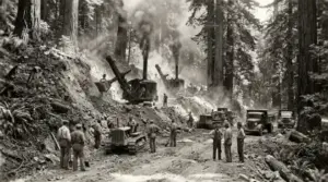
Before asphalt carved through Patchen Pass, traveling across the Santa Cruz Mountains was an arduous, multi-day endeavor. Indigenous Ohlone trails originally traversed the ridges, following natural contours to avoid dense river canyons. In the mid-19th century, timber extraction and the California Gold Rush created an urgent commercial demand for reliable mountain transit.
By the 1860s, private toll road operators established turnpikes, including the Santa Cruz and San Jose Turnpike. Stagecoaches rattled along unpaved, single-lane dirt roads clinging to cliff edges, negotiating mudslides in winter and blinding dust in summer. The opening of the South Pacific Coast Railroad in 1880 provided heavy freight transport through mountain tunnels, but as motor vehicles gained popularity in the early 20th century, the demand for a dedicated automobile highway became undeniable.
In 1934, the California Division of Highways (now Caltrans) completed the original four-lane realigned route over Patchen Pass, officially designating it as State Route 17. The project required massive earthmoving efforts, filling deep ravines and cutting through solid rock cuts to eliminate dozens of hair-pin turns.
Engineering Safety into a Treacherous Corridor
Despite early modernization, Highway 17 earned a formidable reputation as one of Northern California’s most challenging drives. The combination of steep gradients, tight blind curves, dense mountain fog, and heavy winter rainfall frequently resulted in severe cross-median collisions and landslides.
Throughout the late 20th century, transportation engineers implemented targeted civil infrastructure upgrades to tame the mountain pass:
- The Center Concrete Median Barrier: Prior to the 1990s, no physical barrier separated opposing traffic lanes along much of the summit route. The installation of continuous concrete “Jersey” barriers virtually eliminated head-on cross-median collisions.
- Laurel Curve and Intersections: Infamous accident hot spots, such as Laurel Curve and the Bear Creek Road intersection, underwent major re-engineering. The construction of dedicated overpasses—including the Gillian Cichowski Memorial Overpass—replaced dangerous at-grade turns with controlled interchanges.
- High-Friction Surface Treatments: Caltrans applied specialized anti-skid pavement overlays and widened shoulder cutouts to preserve traction during sudden mountain rainstorms.
Battling Earthquakes, Landslides, and Mountain Geology
Highway 17 crosses directly over the active San Andreas Fault zone near the summit. The corridor’s steep mountain slopes make it perpetually vulnerable to seismic disturbance and intense winter saturated mudslides.
The true test of the highway’s infrastructure came during the 6.9-magnitude Loma Prieta Earthquake in October 1989. Massive rockfalls and soil slumps severed the highway near Summit Road, locking large boulders across all lanes and shearing retaining structures. Emergency civil crews worked around the clock, reshaping slope angles, installing soil-nail retaining walls, and rebuilding damaged roadbeds to restore vital supply lines to isolated Santa Cruz communities.
To examine the geological history and seismic hazard mapping of the summit region, explore research published by the USGS Earthquake Hazards Program.
Modern Infrastructure: Wildlife Crossings and Climate Resiliency
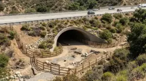
Today, infrastructure design on Highway 17 extends beyond driver safety to encompass ecological preservation and climate adaptation. Operating with an average volume exceeding 60,000 vehicles per day, the highway historically created a major barrier for local wildlife, dissecting critical habitat corridors for mountain lions, black bears, and black-tailed deer.
In an unprecedented conservation milestone, a collaborative effort led by the Land Trust of Santa Cruz County, Caltrans, and local open space agencies completed the Laurel Curve Wildlife Crossing. This specialized underpass tunnel, paired with directional directional fencing, allows animals to navigate safely beneath six lanes of traffic—drastically reducing wildlife-vehicle collisions while reconnecting thousands of acres of protected mountain habitat.
Future Caltrans corridor initiatives continue to focus on stabilizing steep rock cuts, upgrading storm drainage systems to withstand atmospheric rivers, and incorporating smart traffic telemetry sensors to manage commuter flow efficiently.
Conclusion
Highway 17 is far more than a mountain pass; it is a living testament to a century of civil engineering innovation in Santa Cruz County. From early dirt turnpikes cut through virgin redwoods to modern wildlife underpasses and seismic retrofits, the evolution of Highway 17 reflects a continuous balance between human connectivity, rugged geology, and environmental stewardship.